Watoga State Park, WV - Day 3

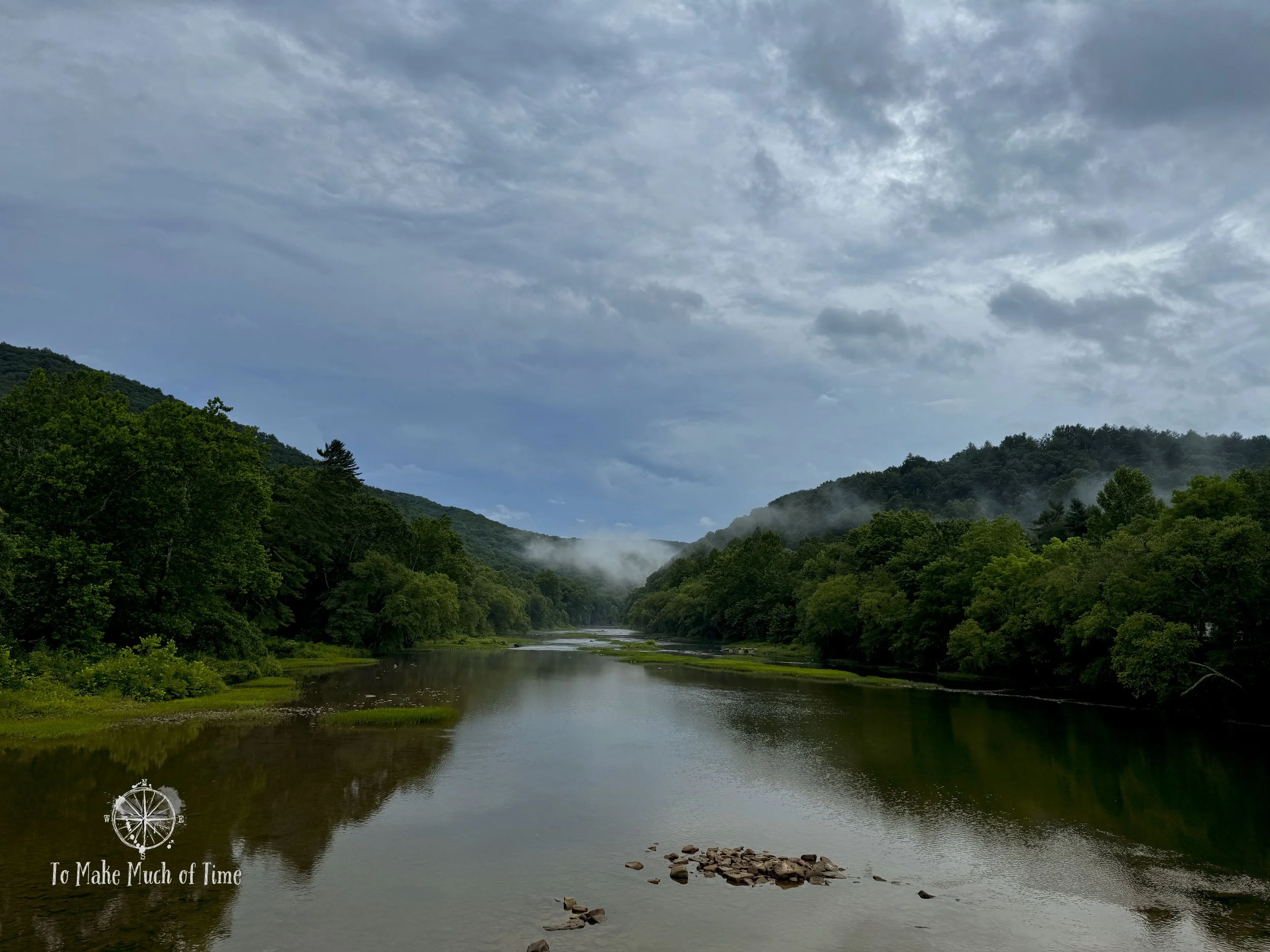
View from Ann Bailey Trail at Watoga State Park, WV
Note: Some links throughout our site are affiliate links, which means we may receive a small commission at no cost to you.
This is the third post in a series for this trip. You can view links to the other posts at the bottom of this one.
On our third full day at Watoga State Park, we hiked Ann Bailey Trail (6 miles roundtrip) out to a fire tower and a loop trail that combined Busch Settlement Trail, North Boundary Trail, Buck & Doe Trail, and Bear Pen Trail (3 miles total). We ended the day by grabbing soft serve ice cream cones from nearby Jack Horner’s Corner.
If you just want to skip to our adventure, scroll on; if you’re looking for some packing tips, here are our top gear recommendations for this trip. You can view more recommendations on our Ultimate Guide to Hiking Gear.
Comfortable hiking clothes - Our favorite options all come from REI. My favorite pants are prAna Halle and these are my favorite lightweight hiking t-shirts. Dustin has a couple of pairs of pants from prAna and the REI brand.
Light-weight raincoat - if there's a chance of rain, you won't regret bringing a lightweight waterproof jacket with you. My favorite is this GORE-TEX jacket, and it has seen many damp trails!
Hiking boots - Our current favorite brand is Oboz. Dustin has their Sawtooth model, and I have the Sapphire.
Hydration backpack - unless you are going for a very short hike, bringing water is a must. Dustin has a very old Camelbak circa 2000, and I have a new-ish one from Gregory that I have used on multiple hiking trips and love. While the Gregory Sula 16 is not currently available, here are some other options. We each have a 3-liter water bladder.
Headlight style flashlight - A headlight, like this one from REI that we each use, was handy for our bike ride through a dark tunnel since our bikes don’t have lights on them.
Day 3: Hiking Ann Bailey Trail and a loop of Busch Settlement, North Boundary, Buck and Doe, and Bear Pen Trails at Watoga State Park
Hiking ann bailey trail
Our morning destination: Ann Bailey Trail, a 3-mile out-and-back (6 mile total) trail near the higher elevations of the park. The Ann Bailey Trailhead is right near the most scenic (car-accessible) part of the park. When we visited two years prior, we spent several evenings up at this look-out point watching the sunset and the moon and stars shine overhead.

Ann Bailey Overlook near trailhead at Watoga State Park

Trailhead for Ann Bailey Trail at Watoga State Park
Just past the car accessible area is the trailhead itself, along with a placard explaining a little bit about Ann Bailey. Born in England in 1742, she made her way to Staunton, Virginia, by 1761. Her husband was killed in 1774 at the Battle of Point Pleasant, after which Ann took up arms to avenge her husband, who had died fighting the Shawnee. She joined the militia and served as a messenger and scout. She later remarried and was stationed at Fort Lee with her second husband. It was from that spot that she reportedly made a 200-mile journey for gunpowder that saved the day in protecting the fort and settlement. Long after her second husband was murdered, Ann Bailey died in her sleep in 1825. For more on the story of this early frontierswoman, check out this site. (Note that many websites spell her name ‘Anne’ but it is spelled ‘Ann’ within Watoga, so I’m intentionally using that spelling.)
The Ann Bailey Trail is entirely a fire road that meanders for 3 miles up and down a wide ridge. The trail is not particularly interesting – mostly the same forest on either sides of the wide path – but still makes for a nice walk. Because of the appeal of the fire tower at the end of the trail, this appears to be a more popular path. We saw two other groups during our hike, which was the most we saw anywhere during our visit. And we saw a black bear scampering by in the forest.

Ann Bailey Trail is a fire road with gravel or dirt most of the way
Nearby on another trail (Jessie’s Cove) is the Workman cabin, named for the pioneer family that lived in it. On the Ann Bailey Trail, we came to the Workman family cemetery, which houses 10 members of that family. In recent years, their descendants have worked to repair the cabin and cemetery. There are four graves that are clearly very new with identical headstones, and the other 6 family members have unmarked graves.

Ann Bailey Trail with a truck used (presumably) to clear the roads
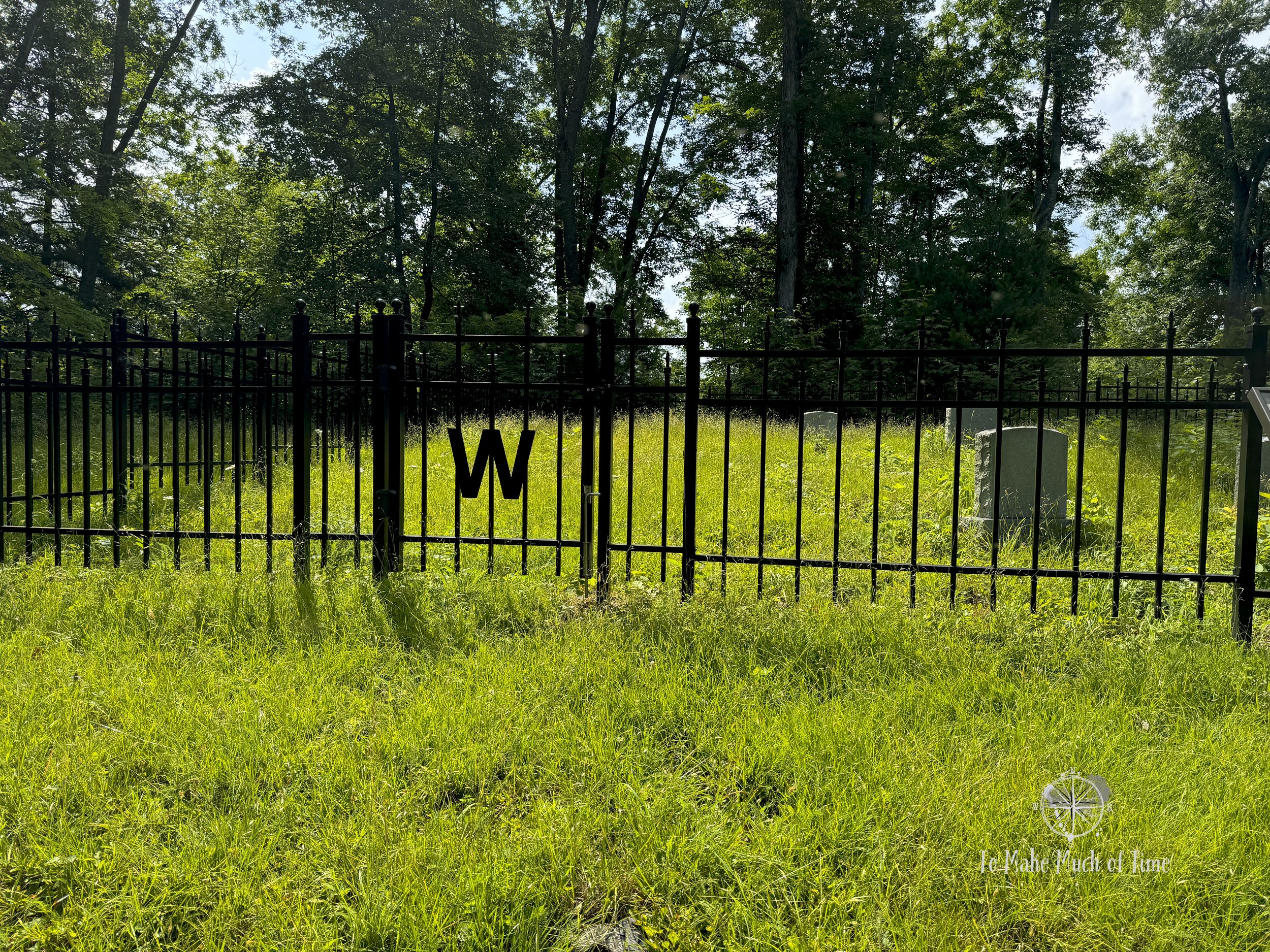
Workman family cemetery along Ann Bailey Trail at Watoga State Park

Ann Bailey Trail at Watoga State Park

Inside the fire tower at the end of Ann Bailey Trail
A short ways on, hikers will be rewarded by coming to the end of the trail. The views from the fire tower are beautiful and worth the three mile hike. The fire tower itself is similar to another fire tower we’ve visited in the region at Droop Mountain Battlefield. It is a loosely constructed log cabin style with spaces between the logs, and it is two stories tall. There were lots of carvings of initials and names in it, some very recent, others from the 70s or 80s, and a few going back as far as the 40s. I’m always dubious whether people put accurate dates but there were a number from that period that did look older so, maybe? The tower itself was built in the 1930s so that makes it possible.

Views from the end of Ann Bailey Trail in Watoga State Park
hiking a loop trail: busch settlement to north boundary to buck and doe to bear pen trails
In the afternoon, we decided to hike a 3-mile loop trail that combined Busch Settlement Trail, North Boundary Trail, Buck and Doe Trail, and Bear Pen Trail. Our original route plan had been a bit different and would have had us starting at the Bear Pen Trail’s access point off the main road; however, when coming back on the Bear Pen Trail the prior day, we noticed a bunch of downed trees fully blocking the original access point we were going to take. So, we pivoted.
Busch Settlement Trail is on the park map, but where they list each trail, their length, and notable features, it is not listed. I’m not sure why. In any case, it took us a minute to locate the trailhead. We took the Busch Settlement Picnic Area turnoff from the main park road and drove around in there a bit before finding the trail.

Busch Settlement / Bear Pen Trail Trailhead is through this gap in the fence and to the left

This sign points the way to the start of the trail once through the fence in the prior image
In hopes of making it easier for others: To find the trailhead after turning into the picnic area, pass the playground (on your left) and then take a left on the long straight road that ends in a gate with a building beyond it. Just in front of that building is a pedestrian entry point and to the left, a tad uphill, is a sign for Bear Pen Trail, which will go a short ways until it meets up with Busch Settlement Trail.
I’m not going to lie: this trail is over a mile pretty much uphill. The uphill is only about 360 feet in elevation, but you’ll notice it. Like other trails, this one hasn’t been maintained very well. There were a number of downed trees and overgrown segments, but none of it was a problem: we could step over the trees easily enough and the overgrown areas were always easy to maneuver while staying on the path.

Signage to the Busch Settlement Trail

Uphill on the Busch Settlement Trail at Watoga State Park

Loop trail in Watoga State Park

Loop trail in Watoga State Park
At the top of the path, we met up with the North Boundary Trail, which we took for half a mile. While this is a different segment than what we’d been on the day prior, it is still a fire road and so an easier, wider path, though rutted and a little muddy in spots. After that, we met up with the Buck and Doe Trail, which is ¾ of a mile in length and headed us back downhill at a faster pace than we’d climbed up. At the bottom, we took a left on the Bear Pen Trail that led us back to the car. While a reasonable hiking route, this was probably my least favorite hike in the park in terms of prettiness and interesting views.

Buck and Doe Trail at Watoga State Park
After 9 miles of hiking throughout the day, we were ready for a relaxing evening off our feet. The prior night when we grabbed a quick bite to eat from Jack Horner’s Corner, we noticed a lot of people stopping in for their soft serve ice cream. So, after eating dinner, we headed over there to enjoy dessert. They have fairly limited options but good ones nonetheless: vanilla, chocolate, or a swirl of both. We each got both chocolate and vanilla in a waffle cone and took it to go. Dustin impressively ensured his ice cream didn’t melt while driving up to the parking lot near the Ann Bailey Trailhead (I, on the other hand, went through all the napkins trying to manage my cone) where we finished our cones and watched the sun set over the layers of mountains.
Click the image below to save this post to Pinterest!

Check out other posts in this trip series: