
Hiking Trails at Carter Caves State Park in Eastern Kentucky
Note: Some links throughout our site are affiliate links, which means we may receive a small commission at no cost to you.
This is the sixth post in a series for this trip. You can view links to the other posts at the bottom of this one.

Wildflower meadow on the 4 Cs trail at Carter Caves State Park in Kentucky
Note: Some links throughout our site are affiliate links, which means we may receive a small commission at no cost to you.
This is the sixth post in a series for this trip. You can view links to the other posts at the bottom of this one.
We spent four full days (and five nights) at Carter Caves State Resort Park. We enjoyed all seven of the park’s hiking trails (about 14.5 miles in total), which varied in length from small connector trails up to 8.5 miles. We also hiked 2 of the 5 multi-use trails, exploring 4.5 miles out of 16.5 miles of those. We visited all 6 of the park’s natural bridges/arches, a significant amount to be housed so close together in one park! In addition to the hikes, the park has amazing caving options - from three guided cave tours to two self-guided options - and I’d recommend you check out our post on that if you’re interested. We really enjoyed the hikes at this park and would recommend others visit!
If you just want to skip to learn about hiking, scroll on; if you’re looking for some tips on what to bring with you, here are our top gear recommendations for this trip. You can view more recommendations on our Ultimate Guide to Hiking Gear.
Comfortable hiking clothes - Our favorite options all come from REI. My favorite pants are prAna Halle and these are my favorite lightweight hiking t-shirts. Dustin has a couple of pairs of pants from prAna and the REI brand.
Light-weight raincoat - if there's a chance of rain, you won't regret bringing a lightweight waterproof jacket with you. My favorite is this GORE-TEX jacket, and it has seen many damp trails!
Hiking boots - Our current favorite brand is Oboz. Dustin has their Sawtooth model, and I have the Sapphire.
Hydration backpack - unless you are going for a very short hike, bringing water is a must. Dustin has a very old Camelbak circa 2000, and I have a new-ish one from Gregory that I have used on multiple hiking trips and love. While the Gregory Sula 16 is not currently available, here are some other options. We each have a 3-liter water bladder.
General Hiking Information for Carter Caves State Park
getting to carter caves state park
Carter Caves State Park is located in Eastern Kentucky, just four miles off of Interstate 64. The closest town is Olive Hill, just under 20 minutes away. The largest nearby city is Huntington, WV, which is about 45 minutes away.
where to stay at carter caves state park
The park itself offers accommodations at the park lodge (similar to hotel rooms), private cabins (which is where we stayed), and RV and tent camping. It is equestrian-friendly for those traveling with their horses, and the 5 multi-use trails are horse friendly. You can learn more about our positive experience with the private cabin in this post.
dining at carter caves state park
There is a restaurant - Tierney’s Cavern - located at the lodge, which serves breakfast, lunch, and dinner. If you need sustenance, this is a great option. We ate lunch there three days and enjoyed the club sandwich the most. While hours vary by day and probably by season, they typically open around 7:30am and stay open until 8 or 9pm, depending on the day. There is usually a 30-60 minute closure between each meal. In addition to food, the restaurant serves beer and wine.
what to know before hiking at carter caves state park
The multi-use trails are for hikers, bikers, and horses. If the two were hiked in full and the others that we temporarily walked along as cut-overs are any indication, these are very muddy trails due to the horse use. If that’s not of interest to you, there are plenty of trails that aren’t multi-use!
Due to the hilliness and rockiness of the area, I’d recommend sturdy hiking boots that cover the ankles. Similarly for those who enjoy hiking sticks or appreciate the stability they offer, bring those. While we don’t use them ourselves, there are a number of rocky segments on several hikes.
Other than the 8.5 mile Carter Caves Cross Country Trail (“4 Cs Trail”) and Box Canyon Trail, the non multi-use trails are very close to the main roads of the park and not isolated.
While there is wildlife in the area and you need to be bear aware, as they say, we only saw chipmunks, squirrels, and deer. Although, we’re pretty sure we saw bear poop on a multi-use trail that was further away from the main park. Keep in mind, the bears in the area would be black bears, which are typically not a threat to humans.
Be aware of the weather. We are not experts on the park or the area’s geology, but throughout our hikes, there were a lot of areas that clearly fill up with water during certain conditions but were dry during our visit. Given that there had been a large storm the day before we got there, our conclusion is that these dry water beds may be typically inundated during quick downpours and be more of a flash flood risk. We’re used to spots that look like this having at least a trickle of water after a storm. A lot of trails traverse these dry creek beds so be extra cautious if there is rain or a thunderstorm in the weather forecast.
Hiking Itinerary at Carter Caves State Park
Given that we had four full days at the park, we had plenty of time to hike any trail we wanted to. We also enjoyed time touring and exploring 5 caves. In some cases, we combined multiple trails or connector options in different ways to avoid back-tracking hikes we’d already taken. What follows below is an overview of the various hikes we took that reflects this approach. The shortest hike we took was 0.8 miles, and the longest (by far) was 8.5 miles. These are not in a specific rank-order but the first handful are generally ones we enjoyed more than those at the end.
HIKING BOX CANYON TRAIL at CARTER CAVES
Quick facts:
0.8 miles in length, took us just over 20 minutes
Home to Cascades Bridges, one of six natural bridges/arches in the park
Located down the street from the main park entrance, easy to find, ample parking
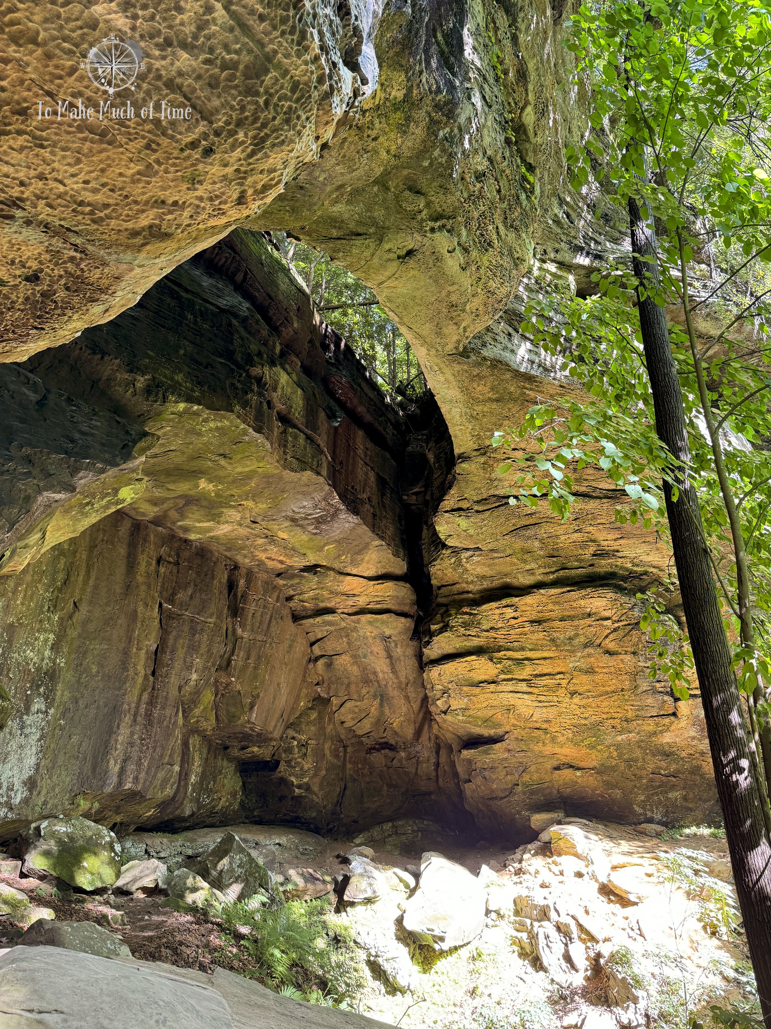
With a little extra time to spare after touring Cascade Caves, which is accessed from the same spot as this hike, we decided on a whim to tackle the Box Canyon Trail. The short trail was absolutely gorgeous. The park brochure calls it the prettiest hike in the park, and I wouldn’t argue with them! The path was very hilly, very green (in late May), rocky at times, and provided amazing vistas of rocky outcrops. Individuals needing extra stability should consider using walking sticks.

Box Canyon Trail at Carter Caves State Park

Box Canyon Trail at Carter Caves State Park

Box Canyon Trail at Carter Caves State Park

We met this Eastern Newt on the Box Canyon Trail. We wasn’t concerned about us at all and stood right in the middle of hte trail while we stepped over him.

Cascade Bridge, a natural arch, is a highlight of the Box Canyon Trail at Carter Caves State Park. It’s one of 6 natural bridges/arches in the park!
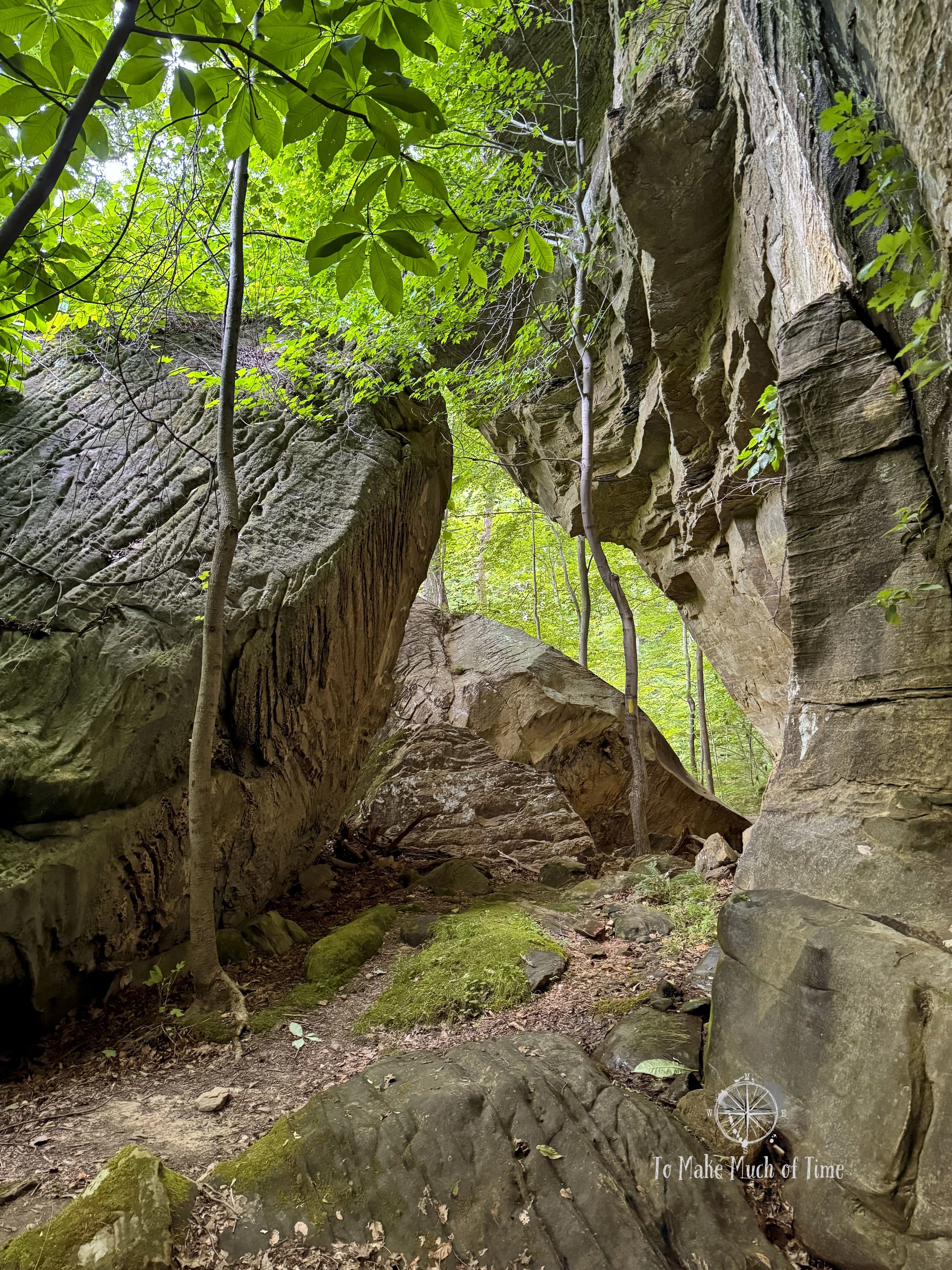
THREE BRIDGES TRAIL AT CARTER CAVES
Quick facts:
3.5 miles in length, took us about 2 hours 15 minutes with plenty of stops to take photos
Home to half of the six natural bridges/arches in the park: Ravens Bridge, Fern Bridge, and Smoky Bridge.
There are several access points to this trail. We joined it near the Lodge. With your back to the front door of the Lodge, you’ll see the road continue to a bit of a cul-de-sac straight ahead. The trailhead is visible right where that road ends. There is ample parking.
Three Bridges Trail is named for the fact that you can access and view three of the park’s six natural bridges/arches from this trail. For those not interested in hiking 3.5 miles to see the three bridges, there are alternative (shorter) ways to see each. Smoky Bridge can be accessed via an approximately 0.3 mile access point behind the Lodge; Raven Bridge can be accessed via the 0.7 mile Raven Bridge Trail (which we also did later in the week and allows for views of the bridge both above it and below it); and Fern Bridge is a bit more isolated but can be accessed from a connector trail near the cabins and a 0.4 mile-ish hike. All that to say, I’d highly recommend doing the full 3.5 mile hike for those able to do so!

The trailhead to Three Bridges Trail is also an access point to Raven Bridge Trail and several other sights.
Three Bridges Trail, after starting near the Lodge, loops around in a large 3.5 mile long circle, eventually passing near the Welcome Center before heading back uphill. This hike is one of the longer hikes and well worth the time and energy. Each of the natural bridges is enormous, beautiful, and a fascinating example of what nature can create with just enough time and the right balance of rock layers and wind and water erosion.
The hike was moderate to difficult, depending on someone’s point of view. It was fairly hilly, at times rocky, and had an elevation change of over 600 feet. We very much enjoyed the route. Note: this path shares about 1.5 miles of its trail with the long trail in the park - the Carter Caves Cross Country Trail (or “4 Cs Trail”). When we did the 4Cs trail later in the week, we selected an alternative path so we didn’t double back through this section. You can read about that below.

Three Bridges Trail at Carter Caves State Park

Three Bridges Trail at Carter Caves State Park

Three Bridges Trail at Carter Caves State Park

Three Bridges Trail at Carter Caves State Park
Three Bridges Trail at Carter Caves State Park

Three Bridges Trail at Carter Caves State Park

carter caves cross country trail (“4 Cs Trail”) AT CARTER CAVES
Quick facts:
8.5 miles in length, took us about 4.5 hours with plenty of stops to take photos. There are clear warning signs in the park about this path. It is on hilly and rocky terrain, is in the backcountry (you’ll likely not pass anyone else during the majority of your time on the path), and they recommend allowing 6 hours for completion. I’d add that there are a lot of creek beds we walked through that were fully dry for us but have signs of significant water. If the weather has just been stormy or threatens to be stormy, I’d be cautious starting out on this, as you may find yourself unable to cross or trying to walk on slippery rocks.
Home to one of the six natural bridges/arches in the park: Shangra La Arch; the route to two permit-required backcountry camping sites; provides views of the lake; and has two suspension bridges, which were fun.
There are several access points to this trail. We joined it near the Lodge by first taking 0.5 miles on the Three Bridges Trail first. The reason we chose this option is that the park map indicates that one section of the trail may be impassible due to high water, and we did not want to get to that spot after a long hike and have to turn around. This access point allowed us to get there as quickly as possible.
We really enjoyed this lengthy hike, and because we wrote so much about it on our post about our fourth day in the park, please read that post if you want to learn more!

Carter Caves Cross Country Trail

Carter Caves Cross Country Trail

1 of 2 suspension bridges on Carter Caves Cross Country Trail

Carter Caves Cross Country Trail

Carter Caves Cross Country Trail
NATURAL BRIDGE TRAIL AT CARTER CAVES
Quick facts:
0.5 miles in length, took us about 15 minutes
This trail is entirely about the Natural Bridge, one of six natural bridges/arches in the park and the easiest to access.
Located downhill from the Welcome Center, there is ample parking. If your back is to the Welcome Center door, the trailhead is to your right. Walk along the sidewalk, and you’ll see signs just past the building. A maintenance road runs alongside the path for a bit.
This path heads downhill to one of the multiple natural bridges (arches) in the park, goes through the arch itself, and then climbs atop the geologic wonder. From atop, you can gaze down through a large hole in the top that was visible from below, which was cool, and then the trail heads back up to the Welcome Center again. Having so many naturally forming arches in one park is really quite spectacular! This short walk is great for people of varying abilities, though I will note that there is a short, steep climb uphill to access the area above the arch and continue the short loop.

Natural Bridge Trail at Carter Caves State Park

Natural Bridge Trail at Carter Caves State Park - looking down into the natural bridge from atop

Natural Bridge at Carter Caves State Park
HORN HOLLOW TRAIL at carter caves
Quick facts:
1.5 miles in length, probably took us 40ish minutes but we stopped midway for a self-guided cave tour, which threw our time tracker off!
A meandering trail through the woods with just a couple hundred feet in elevation change over its course. The real highlight of this trail is the Horn Hollow Cave, which you can visit on your own with a (free) permit. Absent plans to tour that, this hike is nice but not one of our favorites in the park. You can read more about the cave experience here.
Located uphill from the Welcome Center, there is ample parking. If your back is to the Welcome Center door, the trailhead is to your left at the end of the road and up the hill.
Horn Hollow Trail is 1.5 miles with the cave right in the middle of the distance. The trail was nice, wooded, and cut alongside creeks. This might be a good trail for those looking to expose their children to a hike that is on the shorter side.
HIKING RAVEN BRIDGE TRAIL AT CARTER CAVES
Quick facts:
1.3 miles in length, took us about 37 minutes (note: we made a loop that combined Raven Bridge Trail with a portion of Three Bridges Trail and Rockbridge Trail. Alternatively, hikers could walk a similar distance as an out-and-back on just Ravens Bridge Trail)
This is a great route to check out one of the park’s six natural bridges/arches: Raven Bridge.
Located uphill from the Lodge, there is ample parking at the Lodge itself, in the overflow parking, and uphill from the Lodge. The sign for the trail is visible from near the Lodge. With your back to the front door of the Lodge, you’ll see the road continue to a bit of a cul-de-sac straight ahead. The trailhead is visible right where that road ends. This is the same trailhead to join Three Bridges Trail. There is ample parking.
Raven Bridge Trail culminates at none other than Raven Bridge, one of the park’s natural bridges/arches. This one can be viewed from both above and below if you hike down several flights of stairs at the end of the path.
From there, hikers can back-track up the stairs or return to the Lodge area by taking the Three Bridges Trail for a bit. Once on Three Bridges, hikers can take that all the way back to the Lodge or take a cut-over connector trail called Rockhouse Trail (0.1 miles) back up to the Raven Bridge Trail. Since we’d already hiked Three Bridges, we took the connector trail and were glad we did. It held some amazing rock outcrops and rock faces, huge boulders, and was picturesque. This relatively short loop hike we took was through a peaceful, pretty part of the woods and had a few areas of uphill and downhill sprinkled throughout. We ended up with several ticks on us at the end of the day and suspect we picked them up during this part of our hiking, though we don’t know for sure. These were the first ticks we saw on the trip. We also picked some up on the 8.5 mile 4 Cs Trail.

Raven Bridge Trail

Raven Bridge Trail

Raven Bridge from atop at Carter Caves State Park

A close-up of the rocks that make up Raven Bridge
Rockhouse Trail that we used as a connector while hiking to Raven Bridge

Rockhouse Trail that we used as a connector while hiking to Raven Bridge
HIKING MULLIGAN TRAIL AT CARTER CAVES
Quick facts:
2.2 miles in length, took us about 45 minutes
This is the former golf course within the park, and the trail itself is the former golf cart trail, which has eroded over time. This is the least woodsy path we took in the park.
Located uphill from the Lodge, there is ample parking at the Lodge itself, in the overflow parking, and uphill from the Lodge. The sign for the trail is visible from near the Lodge. If you have your back to the Lodge door, walk left along the sidewalk in front of the rooms, and look across the street. You’ll see a narrow road that goes up with the sign.
After spending a few hours indoors in cool cave temperatures, we hiked Mulligan Trail, which gave us a lot of warm sun. There was a vague feel of urban decay to it (which made it cool, in my opinion), and the fields and trees were pretty with rolling hills. While this is not exactly a traditional hike, it was a nice way to spend a little time outdoors in the afternoon. It certainly wouldn’t have made our list of top hikes to take in the park, but with 4 full days here, we had plenty of time for everything.

Mulligan Trail at Carter Caves State Park

Mulligan Trail at Carter Caves State Park

View of the lodge at Carter Caves State Park from the end of Mulligan Trail
HIKING CAVE BRANCH TRAIL AT CARTER CAVES
Quick facts:
3.1 miles in length, took us about 1 hour 20 minutes
This is one of the few multi-use trails we took. This means it is open to hikers, bikers, and horses. Plan for mud.
Located in the nearby Tygarts State Forest but managed by Carter Caves State Park, this trail is a 5-8 minute drive from the main park. It was easy to find. How to get there: Coming out of the park, we took a left on route 182 then another left on a small country road called Oakland Ridge Road. There is a small parking lot, and we were the only ones there during our visit. Alternatively, another access point to the trail is to hike from the Welcome Center on a maintenance road to a small section of two other trails to eventually meet up with the Cave Branch Trail.
Cave Branch Trail certainly lives up to its name as a multi-use trail. It was quite torn up and muddy from horses. We saw plenty of horseshoe prints and no indication of bike tires during our visit. While there were some elevation changes, they were generally mild and spotty so it was a path that we could walk fairly quickly. The path is a loop trail with one length running alongside Cave Branch, a sometime creek. During our visit, it was entirely dry, despite significant rains recently. The woods were pretty and green with the spring leaf growth, and all-in-all, it was a nice walk in the woods, despite the significant muddy sections. This is not a top hiking path in the park and not one that would be enjoyable on a sticky, buggy summer day, but with a slightly cloudy day with temps in the upper 60s, this was a nice way to spend some of the morning. If walking through and around mud annoys you on hikes, I’d skip this one!

Parking lot and trailhead for Cave Branch Loop

Cave Branch Loop

Muddy trail conditions on the multi-use Cave Branch Loop

Example of one of many dry creek beds that Cave Branch Loop crosses over
Click the image below to save this post to Pinterest!

Check out other posts in this trip series:


